

Current Projects
Welcome to our Current Projects page, where we highlight our ongoing projects working with a national wildfire dataset, developing an AI-driven annual snow mapping algorithm, and detecting biotic pest disturbance outbreaks. Explore how SylvaStep Solutions is leading the way in providing innovative environmental solutions.
Environmental Modeling - Wildfire
The first project applies AI and advanced analytics to the Canadian Fire Spread Dataset (CFSDS), a national-scale dataset of wildfire spread. We focus on growth phase classification (ignition, steady growth, blow-up, die-out, shown in the first image), and regional fire–weather relationships (the second image illustrates the Initial Spread Index, ISI). We are now exploring how to use the variables in the dataset to model wildfire spread (third image is a correlation matrix of these variables). By leveraging this dataset, we’re testing new ways to understand and predict wildfire behavior, with more updates to come as the analysis evolves.
Data Fusion - Snow Mapping
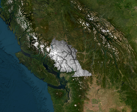
The second project is building on Zoltan Mityok's published MODSAT-NDSI research (click here for the article). By fusing the daily reach of one type of satellite with the fine detail of another, we can generate daily, fine detail snow maps. These were validated against field sites, reaching 90% accuracy. We’re now automating this pipeline for the Stat'imc First Nations territory (see outline of snow map area right) headquartered in Lillooet, BC (statimc.ca). Annual snow cover updates, trend analyses, and habitat applications will be delivered with a single run. This fusion algorithm can be applied not just to snow, but any other satellite dataset: fire severity, vegetation health indices, turbidity mapping, you name it!
On-Demand Earth Analytics - Pest Outbreak Change Detection
The third project involves real-time satellite image querying and spectral analysis to generate change-detection maps for biotic pest outbreaks. In this case, the spruce budworm within the Whistler BC municipality. The work is being done to pinpoint where damage is spreading and how severe it is. This novel method that SylvaStep has developed can acquire imagery for any area of interest, process it instantly, and output spatial products that answer practical, on-the-ground questions. This is a true game changer for forest health monitoring, and for many other spatial questions!
Ready to explore our solutions?
Contact us today for a consultation on how SylvaStep Solutions can help your environmental projects.